
Source: ALJAZEERA
ALJAZEERA MEDIA NETWORK
Overview of Hurricane Beryl's devastating effects and its forecasted path towards Jamaica and the Cayman Islands in HTML format.
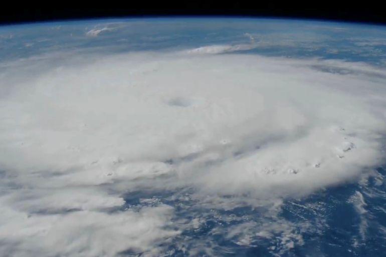
It flattened the island of Carriacou in half an hour on Monday morning and has knocked out 95 percent of the power in Grenada, leaving hospitals without water or electricity. As it hurtles its way across the Caribbean, Hurricane Beryl, one of the strongest ever recorded, is leaving a trail of destruction as it makes its way towards Jamaica and the Cayman Islands.
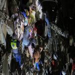
![A woman walks through a debris filled street in the Hastings neighbourhood after Hurricane Beryl passed through Bridgetown, Barbados on July 1, 2024 [Nigel R Browne/Reuters]](https://nowtrends.net/storage/2024/07/93YI1RX7U1WA_CTNV1QY8U8A7.jpg) A woman walks through a debris filled street in the Hastings neighbourhood after Hurricane Beryl passed through Bridgetown, Barbados on July 1, 2024 [Nigel R Browne/Reuters]
A woman walks through a debris filled street in the Hastings neighbourhood after Hurricane Beryl passed through Bridgetown, Barbados on July 1, 2024 [Nigel R Browne/Reuters]
Beryl is the first recorded Atlantic storm to move from Category 1 to Category 5 this early in the hurricane season, which typically runs from the beginning of June to late November. Beyond Grenada, reports say Beryl has reached wind speeds of 270km/h (165 mph).
In a news briefing on Monday, Grenada Prime Minister Dickon Mitchell said, “In half an hour, Carriacou was flattened.” Carriacou is the second-largest island within the state of Grenada.
The US National Hurricane Center (NHC) stated, “This is an extremely dangerous and life-threatening situation.”
Hurricane warnings are in effect for Barbados, where Beryl also passed by on Monday, Grenada, Tobago and St Vincent with tropical storm warnings for Martinique, St Lucia and Trinidad. Grenada is in an extended state of emergency with rainfall of as much as 12 inches (30.5cm) expected in some places.
According to local news, the island of St Lucia, south of Grenada, has experienced downed power lines, blocked roads, scattered tree branches and other debris.
The Dominican Republic and Haiti, where rainfall could reach six inches (15.2cm), have been placed under storm warnings.
In an X post on Monday from the NHC, the center reported a tropical storm warning had also been issued for the south coast of Hispaniola.
On Tuesday morning, Beryl was 1,120km (695 miles) east-southeast of Kingston, Jamaica with sustained winds of 270km/h (165mph), according to the NHC. It is moving quickly in a west-northwesterly direction.
The hurricane is expected to hit Jamaica on Wednesday and the Cayman Islands on Thursday.
According to the US Navy, there are five categories of hurricanes.
In an “Ask a NASA Scientist” video posted by the space center, Mara Cordero-Fuentes, NASA Atmospheric Scientist, said: “When you say, “Are hurricanes getting stronger?” in the sense of, “Are they going to be category 6″, The answer in that case will be no. Because of physics, hurricanes do not reach more than a Category 5.”
Yes. In her “Ask a NASA scientist” post, Cordero-Fuentes said: “We do see more and more hurricanes in the Atlantic every season getting to Category 3, Category 4 or Category 5 compared to seasons 40 years ago.”
In October 2022, a study of tropical cyclones (TCs – another term for hurricanes and typhoons) by Scientific Reports, a peer-reviewed open-access scientific journal published by Nature Portfolio, found an increase in the frequency of cyclones.
The study stated, “The overall frequency and magnitude of quickly intensifying TC events have already increased for the Atlantic basin as the planet and our oceans have warmed over the past 50 years. Furthermore, the locations at which such intensification events occur have also varied.”
Surprisingly hurricanes, cyclones and typhoon are roughly the same. They are all tropical storm weather systems which can have a destructive effect, but the labels are used to differentiate them by geolocation.
In the North Atlantic and Northeast Pacific oceans, the label “hurricane” is used. In the Northwest Pacific Ocean, the term “typhoon” is used. Lastly, the cyclone label is used in the South Pacific and Indian oceans.
These storms are powerful, spinning weather systems with low-pressure areas, warm ocean waters, and strong winds, spanning several hundreds of miles, often leading to heavy rainfall and potential coastal flooding.
There are a multitude of factors but here are the three main ones:

ALJAZEERA MEDIA NETWORK
Your email address will not be published. Required fields are marked *